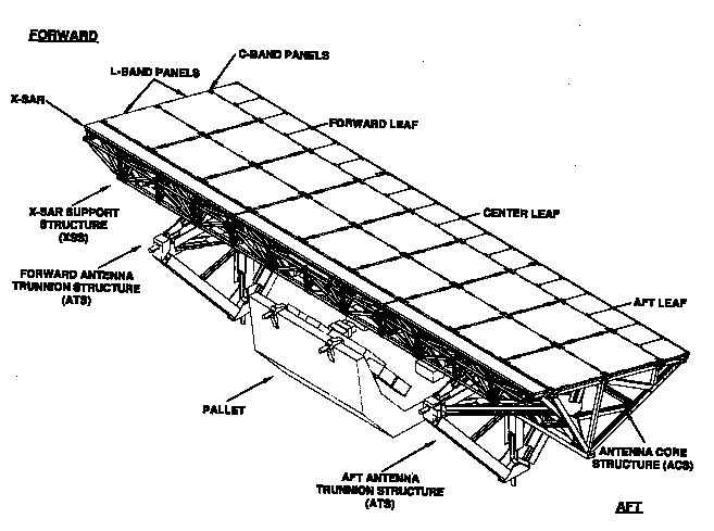
Diagram of the SIR-C/X-SAR payload
Newsgroups: sci.space.news
From: Admin@ccmail.jpl.nasa.gov
Subject: JPL/SIR-C/X-SAR fact sheet
Message-ID: <940128151130.CC1344712@CCMail.Jpl.Nasa.Gov>
Organization: Jet Propulsion Laboratory - Pasadena CA
Date: Fri, 28 Jan 1994 23:14:55 GMT
Approved: sci-space-news@ames.arc.nasa.gov
Lines: 229
Since the late 1970s a variety of NASA satellite missions have used imaging radar to study Earth and our planetary neighbors. The joint U.S./German/Italian Spaceborne Imaging Radar-C/X-band Synthetic Aperture Radar (SIR-C/X-SAR) is the next step in that program.
SIR-C/X-SAR will fly aboard the space shuttle Endeavour in April and August 1994 as part of the Space Radar Laboratory (SRL). These are two of at least three planned flights.
The Space Radar Laboratory, part of NASA's Mission to Planet Earth, is studying how our global environment is changing. From the unique vantage point of space, SIR-C/X-SAR will observe, monitor and assess large-scale environmental processes with a focus on climate change. The spaceborne data, complemented by aircraft and ground studies, will give scientists highly detailed information which will help them distinguish natural environmental changes from those that are the result of human activity. NASA will distribute the Mission to Planet Earth data to the international scientific community so that this essential research is available to people everywhere who are trying to make informed decisions about protecting their environment.
The most useful feature of imaging radar, also called synthetic aperture radar (SAR), is its ability to collect data over virtually any region at any time, regardless of weather or sunlight conditions. The radar waves can penetrate clouds, and under certain conditions the radar can also see through vegetation, ice and dry sand. In many cases, radar is the only way scientists can explore inaccessible regions of Earth's surface.
A synthetic aperture radar transmits pulses of microwave energy toward Earth and collects the energy that is scattered back to the antenna. The motion of the shuttle is used to "synthesize" an antenna (the aperture) that is much longer in length than the actual SIR-C/X-SAR antenna in the shuttle. A longer antenna produces images of finer resolution.
The SIR-C/X-SAR mission is a major technical step forward in the evolution of spaceborne imaging radar. It is the first spaceborne radar system that will simultaneously acquire images at multiple wavelengths and polarizations.
SIR-C, built by the Jet Propulsion Laboratory and the Ball Communications Systems Division for NASA, is a two-frequency radar including L-band (23-cm wavelength) and C-band (6-cm wavelength). SIR-C will have the capability to transmit and receive horizontally and vertically polarized waves at both frequencies.
X-SAR is built by Dornier and Alenia Spazio companies for the German space agency, Deutsche Agentur fuer Raumfahrtangelegenheiten (DARA), and the Italian space agency, Agenzia Spaziale Italiana (ASI). It is a single-polarization radar operating at X-band (3-cm wavelength).
SIR-C/X-SAR is a precursor for free-flyer missions later in this decade.
Scientists will use SIR-C/X-SAR to measure vegetation structure and seasonal changes in wetlands. SIR-C/X-SAR data will also provide measurements of soil moisture and surface roughness, tropical forest flooding, seasonal changes in snow cover and glacier properties, and the distribution of snow over mountainous regions. Oceanographers will use SIR-C/X-SAR to image currents, eddies, frontal boundaries, ocean swells, internal waves and ocean bottom topography.
The radar's ability to penetrate arid soil will help scientists understand Earth's ancient climate and water patterns.
SIR-C/X-SAR will also play an important role in monitoring present-day geologic activity such as volcanic eruptions, tectonics, erosion, and desertification.
Initial plans call for SIR-C/X-SAR to collect a total of 50 hours of data, roughly corresponding to 50 million square kilometers (18 million square miles) of ground coverage. Several "supersites" of extreme scientific interest, such as the Galapagos Islands and the Sahara Desert, have been identified and will be continually monitored during the mission. SIR-C/X-SAR will be flown during different seasons which will allow scientists to make comparative measurements of these same sites.
The scientists will also establish "ground truth" teams that will make simultaneous measurements of vegetation, soil moisture, sea state, snow and weather conditions during the mission. Data from these teams will be supplemented with information taken from aircraft and ships to ensure an accurate interpretation of the data taken from space. In addition, the astronauts will record their personal observations of weather and environmental conditions in coordination with SIR-C/X-SAR operations.
SIR-C is the latest in a series of spaceborne imaging radar missions that began in June 1978 with the launch of JPL's Seasat SAR and continued with SIR-A in November 1981 and with SIR-B in October 1984. Both the SIR-A and SIR-B sensors were derived from the Seasat SAR, and all three were capable of transmitting and receiving horizontally polarized radiation (commonly referred to as HH polarization) at a frequency of 1.28 gigahertz (L-band frequency).
The major difference between the Seasat and SIR-A sensors was the orientation of the radar's antenna with respect to Earth's surface. Microwave radiation transmitted by Seasat struck the surface at a fixed angle of approximately 23 degrees from the local zenith direction. SIR-A was designed to view the surface at a fixed 50 degree angle.
SIR-B improved upon both those missions because its antenna could be mechanically rotated. This allowed SIR-B to obtain multiple radar images of a given target at different angles during successive shuttle orbits.
The X-SAR antenna is a follow-on to Germany's Microwave Remote Sensing Experiment (MRSE) which was flown aboard the first shuttle Spacelab mission in 1983.
The SIR-C antenna is the most massive piece of flight hardware ever built at JPL, and will nearly fill the entire shuttle cargo bay. Its mass is 10,500 kg (23,100 lbs) and it measures 12 meters by 4 meters (39.4 feet by 13.1 feet). The antenna consists of three leaves and each is divided into four subpanels.
Unlike previous SIR missions, the SIR-C radar beam is formed from hundreds of small transmitters embedded in the surface of the radar antenna. By properly phasing the energy from these transmitters, the beam can be electronically steered without physically moving the large radar antenna. This feature will allow images to be acquired from 15 degree to 55 degree angles of incidence. Advancements in radar technology will allow SIR-C to acquire simultaneous images at L-band and C-band frequencies with HH, VV, HV, and VH polarizations.
Polarization describes how the radar wave travels in space. For example, when data is acquired with HH polarization the wave is transmitted from the antenna in the horizontal plane and the antenna receives the backscattered radiation in the horizontal plane. With HV polarization, the wave is transmitted horizontally, but is received by the antenna in the vertical plane. It is the interaction between the transmitted waves and the Earth's surface that determines the polarization of the waves received by the antenna. Multi-polarization data contains more information about surface conditions than single polarization data.
X-SAR will use a slotted-waveguide antenna which is mounted on a bridge structure that is tilted mechanically to align the X- band beam with the L-band and C-band beams. X-SAR will provide VV polarization images.
Both SIR-C and X-SAR can be operated as either stand-alone radars or in conjunction with each other. The width of the ground swath varies from 15 to 90 kilometers (9 to 56 miles), depending on the orientation of the antenna beams. The resolution of the radars can be varied from 10 to 200 meters (33 to 656 feet.)
All data will be stored onboard the shuttle using new high- density, digital, rotary-head tape recorders with portions relayed to the ground via NASA's Tracking and Data Relay Satellite System (TDRSS) data link. There will be 160 digital tape cartridges (similar to VCR tape cartridges) carried aboard the shuttle to record the 50 hours of data.
The mission will return 32 terabits of data (32 by 10^12 bits of data) or the equivalent of 20,000 encyclopedia volumes. The raw data will be digitally processed into images using JPL's advanced digital SAR processor and by processors developed by Germany and Italy for the X-SAR data.
Historically, processing SAR data has required a great deal of computer time on special-purpose computer systems. SIR-C/X-SAR scientists will benefit, however, from rapid advances in computer technology that make it possible to process the images with a standard super mini-class computer. Yet even with these advances, it will still take five months to produce survey images from the large volume of data acquired. Detailed processing will take another nine months to complete. Data will be exchanged among Italy, Germany and the United States to meet the needs of the science investigators.
An international team of 49 science investigators and three associates will conduct the SIR-C/X-SAR experiments. A dozen nations are represented, including: Australia, Austria, Brazil, Canada, China, England, France, Germany, Italy, Japan, Saudi Arabia and the United States.
Dr. Diane Evans of the Jet Propulsion Laboratory is the U.S. project scientist. Dr. Herwig Ottl of DFVLR is the German project scientist and Prof. Mario Calamia of the University of Florence is the Italian project scientist.
The SIR-C mission is managed by the Jet Propulsion Laboratory for NASA's Office of Mission to Planet Earth. Michael Sander is the JPL project manager.
X-SAR is managed by the Joint Project Office (JPO) located near Bonn, Germany. Dr. Manfred Wahl of DARA is the project manager and Dr. Paolo Ammendola of ASI is the deputy project manager.